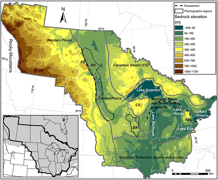
What did North America look like before ice-sheets streamed across it, carving out lakes and flattening fields?
For the first time, a research team including IU scientists has reconstructed a view of North America’s mid-continent, before glaciers changed the landscape forever.
The researchers say their findings enable better understanding of how ice and land co-evolve and illuminate some key climate change questions, including what may happen as current continental ice sheets respond to climate warming and where subsurface water resources may be available.
The study “Landscape evolution under the southern Laurentide Ice Sheet” was recently published in Science Advances.
Tens of thousands of years ago, ice advanced and retreated across the continent, reshaping the land surface and river systems in the process. But the full extent of how the landscape changed has been unclear, because what the terrain looked like before the ice sheets did their work wasn’t known.
“It’s very challenging to know what the initial topography looked like prior to any glaciation, because it’s either covered by ice or eroded away,” said Doug Edmonds, Boyce Chair of Geological Sciences in IU Bloomington’s Department of Earth and Atmospheric Sciences and co-author on the study. “But knowing the starting condition is essential to defining how much erosion or deposition has occurred and where.
“We know the landscape that resulted from glaciation because we live on that surface, but this work allows us to know what the starting point looked like, too,” Edmonds said.
The research team used digital elevation models, data derived from millions of residential and municipal water well logs, and high-powered computer algorithms to reconstruct what the preglacial surface looked like.
The results point out the power of ice in reshaping topography and allow researchers to understand how rock erosion and deposition vary underneath ice sheets, according to hydrogeologist Shawn Naylor. He is former director of the Center for Geospatial Data Analysis at IU Bloomington and currently works with the U.S. Geological Survey’s Ohio-Kentucky-Indiana Water Science Center.
“We found that high ice velocity plays a major role in rock erosion,” Naylor said. “We created the highest resolution bedrock topography map ever generated for the mid-continent. It’s as if we took a very high-powered vacuum cleaner and sucked up all the sediment to reveal what the bedrock surface looks like.”
Knowing the contours of the preglacial landscape and modern bedrock surface can help us better understand water resources, too, said Andrew Wickert, a professor in the Department of Earth and Environmental Sciences and St. Anthony Falls Laboratory at the University of Minnesota, who is also a co-author on the study.
“Water resources and availability are a growing concern as our climate changes,” Wickert said. “Knowing the shape of the buried bedrock surface can help us to identify where ancient valleys are filled by sediments, helping us to predict what kind of water resources may be available and where.”
The reconstructed topography of such a huge section of North America constitutes a big addition to earth science, the researchers say, but they also point to a benefit beyond the scientific impact of their work -- understanding the long evolution of our landscape tells us something about the land we call home.
“Glaciation is probably the most significant event that reshaped North America’s mid-continent, rerouting rivers and leaving behind flatlands in some places and rolling hills in others,” Edmonds said. “There’s something intriguing about seeing our landscape prior to that transformation.”
Brian Yanites, the Robert R. Shrock Professor of Surficial and Sedimentary Geology in IU Bloomington’s Department of Earth and Atmospheric Sciences, was also a co-author on the study.


